
What Happened
American Water is the nation’s largest investor-owned drinking water utility. Its subsidiaries serve more than 3.5 million people in 11 states: Illinois, Indiana, Iowa, Kentucky, Maryland, Missouri, New Jersey, Pennsylvania, Tennessee (including some of Georgia), Virginia, and West Virginia.
In 2017, it was the first investor-owned utility to publicly commit to replacing all lead service lines (LSLs) in its distribution system at no cost to individual customers even if the customer owns part or all of the line.
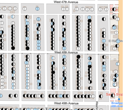
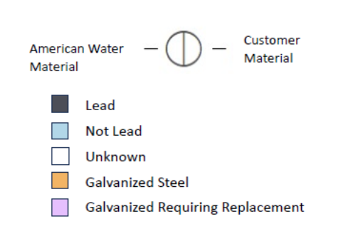
In advance of the October 2024 deadline under EPA’s 2021 Lead and Copper Rule (LCR) Revisions, American Water posted an interactive map of each of the 1.2 million service lines in its system. The map indicates at the address-level, whether a service line is either: 1) lead, 2) not lead, 3) unknown, 4) galvanized steel, or 5) galvanized requiring replacement, for both the portion owned by American Water and the customer.
When a user clicks on a service line, a box opens with additional information depending on the material type. If there is unknown material, users can learn how to check the line as it enters the home and easily report the findings to the utility. If the information may be incorrect, there is a link to ask the utility to fix it. If the line is lead or galvanized requiring replacement, there is a link providing more information on how to get it replaced.
Why it Matters
The LCR Revisions require the more than 1,000 drinking water utilities nationwide serving more than 50,000 people to make their service line inventory publicly accessible online in some manner starting October 16, 2024. Recognizing that Americans commonly use maps as a tool to help plan a trip, check the weather, find a home, or learn more about a community, a neighborhood, or even individual homes, EPA encourages utilities1 to use interactive maps to provide them with familiar means to interactively evaluate information, make decisions, and take action.
In 2019, Hiltner et al.2 evaluated how someone seeking to buy or rent a home would react to three different tools from Ohio utilities. The study concluded that the most useful maps included three things:
- A visual (i.e., map as opposed to database);
- Information about individual properties; and
- Information about both the public and private sides of the service line.
It also found that “when presented with scenarios about purchasing homes with LSLs or with unknown material, respondents overwhelmingly said they would pressure the seller to replace the LSL as a condition of purchase, regardless of the communication tool.” “Fewer respondents were willing to move in and deal with the LSL later on their own. Most respondents indicated that they would prefer to look for another home,” it says. Renters had a similar response. In addition, tools that only provided details on the public side were misleading despite a disclaimer warning them of the omission.
Our Take
American Water’s interactive map is user-friendly and informative, consistent with the recommendations from Hiftner et al. 2019, and is likely to promote LSL replacement. While the material for many service lines, especially for the portion owned by the customer, is marked “unknown,” each of the company’s state subsidiaries have processes in place to identify the material and will regularly update the map.
As explained in a blog earlier this month, our primary concern—one that we have with most of these service line maps—is that the maps do not address the other sources of lead in the home, such as lead-based paint and lead-contaminated dust or soil. Without this information, people concerned about lead exposure are not getting a complete picture and cannot recognize the extent of the risks. However, it is not realistic to ask the utility to include this missing information and are understandably hesitant to appear to be pointing the finger at other sources and deflecting from LSLs as a concern. They look to federal agencies or their related state agencies to provide uniform and realistic guidance. While HUD, EPA, and CDC and some states have developed some tools, more are needed.
- See Section 3.3.2. ↩︎
- Contact Tom Neltner at tneltner@unleadedkids.org for a copy of the study. ↩︎